
I mentioned in my weekly recap that John and I took a Heritage Toronto tour last Sunday. This was fun and informative.
Riding a chartered tour bus we follow the 501 Queen St. streetcar route with the City of Toronto's Chief Curator Wayne Reeves as our guide. We never leave the bus as we explore the neighbourhoods from The Beach in the east to Etobicoke Creek in the west.

Toronto’s centerpiece streetcar route, 501 QUEEN, starts from Long Branch loop on Lake Shore Boulevard near the border with Mississauga. Running east, it serves the main commercial street for the old towns and villages of Long Branch, New Toronto and Mimico before ducking into private right-of-way beneath the Gardiner Expressway and emerging into the Humber Loop interchange.
Exiting the interchange, the line runs east along private right-of-way along the middle of the Queensway, before changing to on-street near Roncesvalles Avenue. After passing Roncesvalles Carhouse, the car follows Queen Street through the old village of Parkdale, the Fashion District, Downtown Toronto, Riverdale, Leslieville, East Toronto and finally into the Beach district, where it loops at Nursewood Road, on the border between the old City of Toronto and the old City of Scarborough. This loop is called Neville loop, even though it is one block east of Neville Park Boulevard.
The QUEEN streetcar has its origins in suburban operations. Horse-drawn trams started running on June 9, 1875 along the Kingston Road Tramway (Queen Street east of the Don River was called Kingston Road at this time) from the Don River to gravel pits west of what is today the Kingston Road-Main Street intersection. The passengers were revenue gravy for this railroad, as the operation was set up originally to haul supplies for the Toronto Gravel Road and Concrete Company. The Kingston Road Tramway turned back at the Benlamond Hotel. In 1878, this line was extended east towards Victoria Park.
This horse-drawn service was abandoned following Toronto’s annexation of Riverdale (1884) and the area south of Queen Street from the Don River east to Maclean Avenue (1887). At that time, the Toronto Street Railway pushed its services east of the Don River to the Woodbine (now Greenwood) Racetrack and Lee Avenue. When the Toronto Railway Company assumed the franchise for streetcar service in the City of Toronto in 1891, the service along Queen was remade into the KING route, operating between Lee Avenue and Dufferin Street via Queen and King. Electric service arrived in 1893, along with an extension east to Balsam Avenue in 1894.
Here is a 501 streetcar just going past Old City Hall. Photo was taken across the street where we were attending a Second Harvest luncheon.

It was difficult to get photos so I will use my archive to document our journey. We meet at City Hall. I took these photos that morning while waiting.
We started our tour with a description of this building. Toronto's present City Hall opened in September, 1965.

It consists of near-twin towers surrounding a white disk-like council chamber, which is mounted on a raised platform with entrances located below. There is also a ramp from connecting the square to the podium roof, from which there is access to the council chamber. The two towers are of unequal height, the east tower being taller than the west. The building was nicknamed "The Eye of the Government" because it resembles a large eye in a plan view. Revell died a year before New City Hall was completed.

Old City Hall across from new City hall. We'll come by Old City Hall at the end of the tour.
Rising majestically between two icons of the City's nineteenth century architecture - Osgoode Hall to the west and Old City Hall to the east - the new City Hall defined modern Toronto, in its anticipated role as the ideal metropolis of the 1960s, '70s and '80s.

At 24.8 kilometres (15.4 mi), it is the TTC's longest surface route, the longest streetcar route operating in North America and one of the longest streetcar routes operating in the world.
Within half a block is Osgoode Hall. Click here for a detailed visit and lunch at Osgoode Hall.
It was constructed between 1829 and 1832 in the late Georgian Palladian and Neoclassical styles. It houses the Ontario Court of Appeal, the Divisional Court of the Superior Court of Justice, and the offices of The Law Society of Upper Canada. The portico of Osgoode Hall's east wing was built at the head of Toronto's York Street to serve as a terminating vista, though it is now obscured by trees planted on the building's lawn.


Osgoode Hall's fence is one of its most recognizable features. Today, it stands as one of the few remaining ornamental iron fences - not only in Toronto, but also in Canada.
The fence's gates are the stuff of Toronto urban legend: were they really built to keep cows from munching the manicured lawn of Osgoode Hall?
The guide referred to these gates as the "cow gates". I have also seen them referred to as kissing gates.
Part of its stately charm is the cast-iron fence that surrounds it and the unusual “kissing gates,” which mimic rural gateways designed to keep livestock from wandering. Long-standing tradition has it that the entrances were installed for just that purpose: to keep itinerant 19th-century cattle from gumming up the wheels of justice.
Is the legend true? Architectural drawings by William Storm, who supervised the 1860 expansion that included the fence, actually referred to the gates as “cattle guards.” And they work: in 1950 a group of students attempted unsuccessfully to bring a cow through one of the entrances.
Our guide felt that this was the most reasonable explanation for the gates.
Mid-19th-century Toronto was a dangerous and unpredictable place, and even if cattle stampedes weren’t a risk, the unusual design would also have made it harder for herds of humans to storm the grounds. It had only been 22 years since the failed Upper Canada Rebellion, and a subsequent influx of poor, Catholic, and vehemently anti-Imperial Irish was shaking up the staunchly Protestant establishment. Brawls and full-on riots sparked by conflict between the new arrivals and Orange gangs weren’t uncommon.
Given that there are few things more likely to unite opposing mobs than a mutual contempt for the legal profession, it might have seemed wise to install gates at Osgoode Hall that would allow passage to only one rioter at a time, the easier to club and stack the miscreants in neat rows by religious denomination.

Looking up University St.
This portion of University Avenue between Queen Street West and College Street is laid out as a boulevard, with memorials, statues, gardens, and fountains concentrated in a landscaped median dividing the opposite directions of travel.
Commissioned in 1910, largely as the result of the efforts of James Mason, and designed by Walter Seymour Allward to commemorate Canada's participation in the Boer War, it consists of three bronze figures at the base of a granite column. Another bronze figure is found at the top of the memorial.


At the corner of Queen and University sits Campbell House.

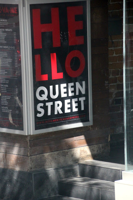
We are now into the first of the trendy sections of Queen St. W. As we continue westward we will enter many neighbourhoods defined by the emigrants who settled there.
Queen (then known as Lot Street) "was the baseline established by the Royal Engineers, when they laid out the town of York (now Toronto) in 1793." At the behest of Lieutenant-Governor John Graves Simcoe, much of York was divided into 41 lots, the boundary lines of which define our current streetscape.
"They had narrow frontages (660 feet) on Lot Street (today's Queen Street), to allow all owners access to the town and harbour. The lots were ten times as deep (6,600 feet) as they were wide and extended north to today's Bloor Street. There were 32 Park Lots running from the Don River, west to about today's Lansdowne Avenue. From there, west to the Humber River, the land was divided into nine "Township" lots, following the pattern of the Park Lots, but double the width. They were 200 acres each, more or less, as the contours of Lake Ontario and the Humber River would allow. The Park Lots closest to the Town of York were the most desirable, and the status of the persons to whom they were granted reflected this."

It is fascinating about Queen Street that many of the street's buildings remain from the turn of the century. Many of them have been altered or added to in some way, but if you look closely enough, you'll see that they've been around for the long haul.


With its 1913 neo-Gothic terra cotta façade, the building is designated as a heritage property by the City of Toronto's Heritage Preservation Services under the Ontario Heritage Act and has served as a broadcast facility since 1987.


In the early 1800's, Trinity-Bellwoods was part of a tract of land belonging to Captain Samuel Smith. Smith named his one hundred acre Park Lot 'Gore Vale'. Gore was in honour of Lieutenant-Governor Francis Gore, and Vale denoted the ravine that is now Trinity-Bellwoods Park.
.

The lower half of Gore Vale became the grounds of Trinity College, after which this neighbourhood is named. Trinity College was built in 1852, on the site where Trinity-Bellwoods Park is now situated. The entrance gates to Trinity College are still standing at the foot of Queen Street and Strachan Avenue, and serve as a lonely reminder of this once proud institution.


There are internationally-renowned venues like the Cameron House, the Horseshoe and the Rex. This mural changes constantly.
Mid-19th-century Toronto was a dangerous and unpredictable place, and even if cattle stampedes weren’t a risk, the unusual design would also have made it harder for herds of humans to storm the grounds. It had only been 22 years since the failed Upper Canada Rebellion, and a subsequent influx of poor, Catholic, and vehemently anti-Imperial Irish was shaking up the staunchly Protestant establishment. Brawls and full-on riots sparked by conflict between the new arrivals and Orange gangs weren’t uncommon.
Given that there are few things more likely to unite opposing mobs than a mutual contempt for the legal profession, it might have seemed wise to install gates at Osgoode Hall that would allow passage to only one rioter at a time, the easier to club and stack the miscreants in neat rows by religious denomination.

This portion of University Avenue between Queen Street West and College Street is laid out as a boulevard, with memorials, statues, gardens, and fountains concentrated in a landscaped median dividing the opposite directions of travel.
Commissioned in 1910, largely as the result of the efforts of James Mason, and designed by Walter Seymour Allward to commemorate Canada's participation in the Boer War, it consists of three bronze figures at the base of a granite column. Another bronze figure is found at the top of the memorial.


At the corner of Queen and University sits Campbell House.

We are now into the first of the trendy sections of Queen St. W. As we continue westward we will enter many neighbourhoods defined by the emigrants who settled there.

The heritage buildings along Queen W have been reinvented many times.
Queen (then known as Lot Street) "was the baseline established by the Royal Engineers, when they laid out the town of York (now Toronto) in 1793." At the behest of Lieutenant-Governor John Graves Simcoe, much of York was divided into 41 lots, the boundary lines of which define our current streetscape.
"They had narrow frontages (660 feet) on Lot Street (today's Queen Street), to allow all owners access to the town and harbour. The lots were ten times as deep (6,600 feet) as they were wide and extended north to today's Bloor Street. There were 32 Park Lots running from the Don River, west to about today's Lansdowne Avenue. From there, west to the Humber River, the land was divided into nine "Township" lots, following the pattern of the Park Lots, but double the width. They were 200 acres each, more or less, as the contours of Lake Ontario and the Humber River would allow. The Park Lots closest to the Town of York were the most desirable, and the status of the persons to whom they were granted reflected this."


These guys are sitting atop the building that houses Bell Canada's broadcast media hub. It is still often called the City TV building.


Hatmakers since 1895.

.

The lower half of Gore Vale became the grounds of Trinity College, after which this neighbourhood is named. Trinity College was built in 1852, on the site where Trinity-Bellwoods Park is now situated. The entrance gates to Trinity College are still standing at the foot of Queen Street and Strachan Avenue, and serve as a lonely reminder of this once proud institution.

These factories have been converted into condos.


There are internationally-renowned venues like the Cameron House, the Horseshoe and the Rex. This mural changes constantly.

Gladstone Hotel
The Gladstone Hotel is the oldest continuously operating hotel in Toronto, originally built in 1889 there’s a lot of interesting history behind these walls.
The Gladstone was originally built in 1889 as a stylish hostelry across from the then existing Parkdale railroad station which serviced the Grand Trunk, the Canadian Pacific Railway (CPR), and the Canadian National Railway (CNR) companies.
The location of the Gladstone Hotel, just east of Dufferin on Queen Street West, was once considered the western edge of Toronto and it provided accommodations to travellers from the Parkdale train station as well as visitors and exhibitors at the Canadian National Exhibition.
The building permit was issued in September 1889 for a value of $30,000.00
The original owner, Susanna Robinson, was a widow who operated and lived at the hotel with her 13 children. Susanna and her husband Nixon, a Toronto brewer, had previously operated the Red Lion Hotel in Kleinberg. Mr. Robinson died prior to completed construction of the Gladstone Hotel. In fact, the hotel has always been operated as a family enterprise and continues to do so today under current ownership of the Zeidler family.

We're now at Dufferin and Queen St. W I don't have any photos of the underpass but found these at Lost Toronto.
Looking at the north side of Queen and east towards the subway.
The Gladstone Hotel can be seen in the distance.
The Gladstone Hotel can be seen in the distance.
 The same view in 2010
We will now pass under an old underpass, or subway as it was originally called, is lined with walls of massive limestone blocks. On the north side of Queen, there’s a big piece of sculpted limestone.
“Queen St. Subway,” it reads.
Beneath that, in raised lettering, are the names “R.J. Fleming, Mayor” and “E.H. Keating, City Engineer,” followed by the date in large numerals, “1897,” the year of Queen Victoria’s Diamond Jubilee.
The whole structure speaks to a time when civic leaders dreamed in big, Imperial terms, laying the foundation for assumed greatness. Grand flourishes like the Queen Subway were being built for the ages.
We continue through the neighbourhood of Parkdale which is on my list to explore this summer so pictures to come.
Then cross Roncesvalles and we are on the Queensway, this is our neighbourhood. Famous in the springtime for the cherry trees but a great place at any time of year.
It spans 161 hectares (400 acres), and is a mixed recreational and natural park, with sporting facilities, cultural facilities, educational facilities, gardens, playgrounds and a zoo. One third of the park remains in a natural state, with a rare oak savannah ecology. High Park was opened to the public in 1876 and is based on a bequest of land from John George Howard to the City of Toronto. It is the largest park entirely within the city.
It spans 161 hectares (400 acres), and is a mixed recreational and natural park, with sporting facilities, cultural facilities, educational facilities, gardens, playgrounds and a zoo. One third of the park remains in a natural state, with a rare oak savannah ecology. High Park was opened to the public in 1876 and is based on a bequest of land from John George Howard to the City of Toronto. It is the largest park entirely within the city.

Grenadier Lake.
There are a number of urban legends about how Grenadier Pond came to be named. The version with the most traction concerns the watery demise of an unspecified number of grenadiers attached to the Eighth Regiment of Foot, based at Fort York during the War of 1812.
The story goes that during the Battle of York in 1813, while in hot pursuit of retreating American troops, several members of the regiment broke through the icy surface of Grenadier Pond and drowned.

Humber Loop as seen from our condo. It is smack in the middle of this photo. We are travelling along the Queensway the street running in front of that large white complex.
It is the Humber Waste Treatment Plant opened in 1960.
The Humber works to treat "used" water that residents and businesses deposit down drains every day. Flushing toilets, taking a shower and running a washing machine, for example, produce wastewater. This water travels through the sanitary sewer system, a network of underground pipes, to treatment facilities.
Fast facts about the Humber
Began operating in 1960
Starting capacity for treating wastewater was 227,000 cubic metres
Current capacity is 473,000 cubic metres
Serves a population of approximately 651,000 (Etobicoke, York, portion of the west end of North York, and Toronto
Located on 45.3 hectares/112 acres in the west end
On the left is the Ontario Food Terminal.
The OFT was completed in June 1954 and replaced the Wholesale Fruit Market located west of St. Lawrence Market at the The Esplanade. The land had been purchased in 1946 but plans to build on the site were shelved in 1950 due to the scarcity of building materials. It cost $3 million and took two years to build. The architects were Shore and Moffat and Soules Construction Limited built the facility. It included space for 400 trucks.
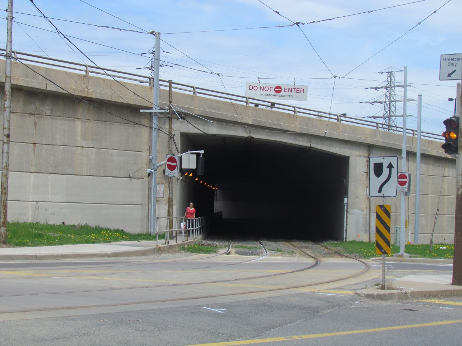
As we can't go through the Humber Loop (for streetcars only) turn down Park Lawn and continue west along the streetcar route along Lake Shore Blvd.
This is the tunnel for the streetcars. We cut through here to go to the Queensway.
I had wondered why there were a lot of 4 and 5 story rental apartments along here and learned they were built after World War II for the returning soldiers.
There are wonderful murals along here. An example in keeping with our heritage theme.

Someone asked if there used to be a Campbell's Soup company around here and the answer is yes.
On November 28, 1930, the wholesome, convenient goodness of the famous “red and white label” finally came to Canada. Nine months later in New Toronto, just north of Lake Ontario, Campbell’s Toronto Plant opened its doors and quite literally fired-up the kettles!
Some can still remember the early days, when the start of tomato soup production season marked the town with “help needed” notices written on the sidewalks of Lakeshore Boulevard in chalk.

We reach the end of Toronto and turn around at Marie Curtis Park.
Marie Curtis Park is a public park. It is located at the mouth of the Etobicoke Creek on Lake Ontario in the Long Branch neighbourhood. Etobicoke Creek is the boundary of Toronto on the east and Mississauga to the west. Marie Curtis Park was built after the devastating floods of Hurricane Hazel in 1954 destroyed 56 homes and cottages on the site, leaving 365 persons homeless and seven dead. It is named after a reeve of Long Branch, a village now amalgamated into the City of Toronto.

The journey now eastbound is along Lake Shore Blvd. We make a couple of stops.
The village of Long Branch began as a summer resort. The first residents were Colonel Samuel Smith of the Queens Rangers, his family and servants who lived in a house on the south side of the Lake Shore Highway just east of Etobicoke Creek.
What contributed to the exclusivity of the area was its relative isolation not only from the city, but also from the nearby communities (in case of New Toronto, it was also social - the town was decidedly industrial working-class in character). To arrive at their resort, vacationers had to embark on a journey on the Grand Trunk Railway and get off at the Long Branch station. Another travel option was the steamers, such as Greyhound or the White Star, which boarded at the foot of Yonge Street, then sailed the passengers along the lake.
We will be back to get photos of this area.

Our last diversion in the west end is at the Humber College campus. The campus is on the grounds of the old asylum hospital and some of the buildings are used today.

The asylum opened on January 21, 1889 and closed down on September 1, 1979. It was originally known as the Mimico Branch Asylum, as it formed part of the Provincial Lunatic Asylum at 999 Queen Street West in Toronto, Ontario, caring only the chronically ill. Between 1889 and 1979, it was also referred to as the Mimico Insane Asylum (renamed 1894, becoming a seperate institution that offered treatment to all types of patients), Ontario Hospital, Mimico (1920), and later Ontario Hospital, New Toronto (1934). In 1964, the name was changed again to Lakeshore Psychiatric Hospital.


We follow the shore of Lake Ontario in bumper to bumper traffic until we pass the Princes' Gate and continue.

Known as The Toy Soldiers done by Douglas Coupland. The gold standing soldier is wearing the 1813 Royal Newfoundland Regiment uniform and the silver soldier lying down is wearing the 16th United States Infantry Regiment uniform.
The soldiers represent British North America’s success in resisting the U.S. invasion during the War of 1812.

We pass the downtown core and turn back onto Queen St. East.
St. Lawrence Hall.

We enter the neighbourhood known as The Beaches or lately as The Beach. I agree with the curator who says it should be Beaches as they are several beaches along this portion of Lake Ontario.
In the early 1900s the Beach district was considered ‘cottage country’ for Toronto. Winter service was sparse because it was felt that there were too few year-round residents to justify full service beyond Lee Avenue. Starting in late 1895, though, every second streetcar operated all the way to Balsam Avenue.


Black's established in 1911.


We reach the easternmost part of Toronto and take a detour to see the R. C. Harris filtration building.is both a crucial piece of infrastructure and an architecturally acclaimed historic building named after the long-time commissioner of Toronto's public works R.C. Harris.


We have turned west once again on our final leg.
The Ashbridge Estate is on my list to visit. UPDATE we visited both Ashbridge and the Dominion Hotel later that summer.
The Ashbridge family was one of the founding families of Toronto (formerly York); they immigrated to York from Pennsylvania in 1793. They are also the only Toronto family to occupy their land continuously for 200 years. Two acres of the original homestead and an 1854 house have been preserved to tell their story.
The oldest house remaining on the site, the Jesse Ashbridge House was built in 1854 according to a design by Joseph Sheard, architect and Toronto mayor (1871-72). He successfully blended Neo-Classical brick quoins and decorative cornice brickwork with the more picturesque Regency style as seen in the veranda's bellcast roof and fanciful arcaded treillage. The Shingle Style mansard roof was added c. 1899 and it cleverly avoids the difficulty of having to match new bricks to old. While three architectural styles are found on the front façade alone, they nonetheless coexist harmoniously.

The Dominion hotel was constructed in 1889. Its first owner was Robert T. Davies, who founded the Dominion Brewery to the west of the building (now Dominion Square) in 1877. Davies had previously been the manager of the nearby Don Brewery, owned by his relative Thomas Davies.
As originally constructed, the hotel was four stories tall, had a mansard roof, and a small tower. The top floor, once "boasted an elegant performance space". Sometime after 1945 the structure lost its fourth floor, mansard roof and tower.
This has been renovated and includes a pub and restaurant so it requires a visit also.


Cool restaurant.


Almost done! Old City Hall.


And we're done. I don't know about you but I'm exhausted putting this post together. It took longer than the bus tour!

wonderful tour, thanks for taking me along
ReplyDeleteOh wow, what an extensive post with so many details. Love the murals and green spots. Thanks so much for taking us along. Thank you for linking in with Through my Lens.
ReplyDeleteMersad
Mersad Donko Photography
What an informative tour, Jackie! :) I may have to impose penalty points for 'not walking'. Just kidding!
ReplyDeleteGreat tour and fabulous recap.
ReplyDeletewonderful tour!
ReplyDeleteThis is very informative. I especially liked seeing the sculptures and art work.
ReplyDeleteGreat tour and I loved that you took the time to pull photos from your archives to show us the sites. (I've done that and it does take hours). You've made me realize it has been far too long since we visited Toronto - time to go back again!
ReplyDeleteToronto looks beautiful! I like the different architectural styles and open spaces. A comprehensive tour like this one sounds wonderful. So much to discover!
ReplyDeleteLove the buildings in Queens Street and the reflections in the windows - and all of the murals. :)
ReplyDeleteFab tour, Jackie. I spent a lot of time in Toronto when I was in corporate Canada. I worked for two companies that had head offices in Markham. I never really had the time to be a tourist. I'd like to go back now, and spend some time getting to know the city. I'm passing through this summer on the way back to Seoul, but I'll just be seeing the airport. I think my stopover time is less than two hours. Thanks for linking up this week. #TPThursday
ReplyDeleteToronto definitely looks like a place I need to visit. There is so much to see.
ReplyDeleteLisa @ Life Thur the Lens
I recognised some of this (the central parts) but mostly it was new. I often think I should take the tour bus round my own city to get a new perspective - great idea!
ReplyDeleteThe Glasgow Gallivanter