Showing posts with label roadside attractions. Show all posts

11 September 2022

Day 7 - Newfoundland Labrador Viking Trail 2022 - Day 1

 Sep 10 (Tour Day 1) - Port aux Basques to Deer Lake Newfoundland

WEATHER warm and wind northeast 30 km/h gusting to 60
TEMP 18-22 C    TIME 1.5 HOURS AHEAD OF TORONTO\


This is considered to be Day 1 of the tour, however, as in all tours, it is a day to get to the starting destination. This tour starts in Corner Brook population 20,000. But the airport is in Deer Lake about 4 miles away. Since we are driving, the tour said we should stay in Deer Lake as that is where the tour ends.
They will arrange for our car to stay at the hotel - booked by them. Charge applies.

So we start the day driving from Port aux Basques to Deer Lake, NL. The drive is approximately 3 hours.


Breezy enough to put on sweaters as we head to DEER LAKE NL.


It is very quiet on the Trans Canada Highway TCH.


On impulse mistake we took a detour to the town of Stephenville as the billboard said "worth the intrusion"! Nope, not.


Katarina Mirabelle Roxon ONL (Order of Newfoundland and Labrador) is a Paralympic Swimming Champion from Canada. In 2016 she won a gold medal in the 100 metre breaststroke at the 2016 Summer Paralympics in Rio de Janeiro and was the only representative of Canada there in S9, SB8 and SM9 disability classifications.


Yes, it was worth it for this sign! 
As a friend said when I sent it to her... you can get your teeth and laundry cleaned while your taxes are getting done,then ha ve a drink to celebrate your new tattoo!!!! And only park your car once!!!! and....if it's a Friday join in with Karaoke !!!


A tribute to the Queen on this church.


Corner Brook, we will be staying here on our way back.


Gorgeous views outside Corner Brook.


Overnight in Deer Lake hotel booked BY TOUR Holiday Inn Express


26 May 2020

Tuesday Treasures Around the World

Tom the backroads traveller
Travel Tuesday
Our World Tuesday
Image-in-ing
My Corner of the World


April 2006 - Four Corners NM


Another trip, pre-blogging days!


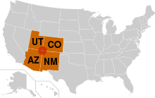
The Four Corners Monument marks the quadripoint in the Southwestern United States where the states of Arizona, Colorado, New Mexico and Utah meet. It is the only point in the United States shared by four states.


One of the specialties in this area is Indian fry bread, a tradition to the Navajo. I have eaten it several times and just love it.


The Navajo planters lived from the earth as their ancestors had for hundreds of years before. They also raised livestock to feed their family. The Navajo dinetah (or homeland) was bordered by the four sacred mountains, from northeastern Arizona, western New Mexico, and north into Utah and Colorado. They planted crops in the fertile valley lands, such as Canyon de Chelly known for Ansazi ruins.
The Navajo traded with the Spanish, Mexican, Pueblos, Apache, Comanche ,and even the early American pioneers. Around 1846, large numbers of pioneers moved into the area and the cavalry came with them. This is when troubles began.  The troubles escalated with the murder or Narbona (1766-1849), a well-respected Navajo leader on August 31, 1849. 
On this day, Narbona along with several hundred of his warriors, had come to meet and discuss peace with U.S. Colonel John M. Washington and others of the military stationed in the area. There had been trouble with the “New Men”, the New Mexican settlers who had driven Mexican settlers out of the area.
After several hours, it was believed a settlement had been agreed upon. However, a young warrior by the name of Sadoval, had plans of his own.  Mounting his horse he began to ride in front of the Navajo party, attempting to have them break the treaty.  A U.S. Calvary soldier began to say that one of the horses ridden by a Navajo was his, and what peace there was in the meeting that was disintegrating into battle. 
Colonel Washington commanded the Navajo to stand down and return the horse to the soldier or he would fire into them. The rider and horse were now gone, and the Navajo party did not comply.  A canon was fired, and Narbona was mortally wounded.  It is told that he was scalped by a U.S. soldier as he lay dying. 
This disastrous attempt at peace led to the “Long Walks”. In September 1863, Kit Carson (1809-1868) was dispatched into Navajo land to retrieve a surrender. When no Navajo came to meet with him, he ordered the burning of the land. Attempts were made to starve out the Navajo, and many were captured and taken to Bosque Redondo near Fort Sumner. Hundreds starved on the 300 mile walk, and more would die later in the crowded and disparaging conditions. Navajo were placed with the Mescalero Apache were home peace was often not the case. The camps were meant for 4,000 to 5,000 people, yet there were now over 9,000 people, and supplies were meager.
The government supplies of lard, flour, salt, sugar, baking powder or yeast, and powdered milk were often rancid. Fry bread came from these few foods provided during the 4 years of captivity.  Since that time, it has become common food at most all PowWows of numerous tribes
To some, Indian Fry Bread is a sacred tradition. It is to be consumed by the people until the earth has again become purified. 


Navajo Fry Bread Recipe 
Fry bread is wonderfully lumpy (puffed here and there). It can be served as a dessert or used as a main dish bread. Our family will often take them and stuff them, much like one might use bread or tortilla to dip into their food.

Yields: makes 4
Prep time: 15 min
Cook time: 8 min

Ingredients:
1 cup unbleached flour
1/4 teaspoon salt
1 teaspoon powdered milk
1 teaspoon baking powder
1/2 cup waterVegetable oil for frying

Preparation:
Sift together the flour, salt, powdered milk, and baking powder into a large bowl. Pour the water over the flour mixture all at once and stir the dough with a fork until it starts to form one big clump.

Flour your hands. Using your hands, begin to mix the dough, trying to get all the flour into the mixture to form a ball. NOTE: You want to mix this well, but you do NOT want to knead it. Kneading it will make for a heavy Fry Bread when cooked. The inside of the dough ball should still be sticky after it is formed, while the outside will be well floured.

Cut the dough into four (4) pieces. Using your floured hands, shape, stretch, pat, and form a disk of about 5 to 7 inches in diameter. NOTE: Don’t worry about it being round. As Grandma Felipa would say “it doesn’t roll into your mouth.”

Heat the vegetable oil to about 350 degrees F. NOTE: You can check by either dropping a small piece of dough in the hot oil and seeing if it begins to fry, or by dipping the end of a wooden spoon in and seeing if that bubbles. Your oil should be about 1-inch deep in a large cast-iron skillet or other large fryer.

Take the formed dough and gently place it into the oil, being careful not to splatter the hot oil. Press down on the dough as it fries so the top is submersed into the hot oil. Fry until brown, and then flip to fry the other side. Each side will take about 3 to 4 minutes.

Indian Fry Bread can be kept warm in a 200 degree F. oven for up to 1 hour. They refrigerate well and can be reheated in a 350 degree F. oven for 10 to 15 minutes before serving.

01 March 2019

Weekend Roundup

Welcome to The Weekend Roundup...hosted by Tom The Back Roads Traveler
ABC Wednesday

1. Starts with "I."
2. A Favorite
3.  INSIDE


Starts with "I"

Toronto ON

An inuksuk is a manmade stone landmark or cairn built for use by the Inuit, Iñupiat, Kalaallit, Yupik, and other peoples of the Arctic region of North America.


FAVOURITE

Indian Head Saskatchewan


The Indian Head was officially unveiled on August 4, 1985. The statue is 18 feet high (the head itself is 10 feet tall). It weighs approximately 3,500 pounds and is made from metal pipe, metal mesh and cement. The statue was designed by Don Foulds of Saskatoon.


INSIDE

Tequila is distilling inside this barrel in La Noria Mexico.


24 November 2014

Cadillac Ranch


Continuing with our travels along Route 66 featuring iconic motel signs and other landmarks.

November and December 2012 saw us taking our first winter sojourn away from cold and snowy Toronto. We drove across from Toronto to (eventually) Los Angeles and back in the spring of 2013. We made many stops along the towns of Route 66 on interstate 40.

Winter 2013 and spring 2014 saw us do the same trip but we took interstate 10, further south from Route 66.

A trip to Chicago gave us another Route 66 photo op.

In earlier years we had taken many vacations in California which also led to some Route 66 icons.

I am enjoying doing these posts as I research the hotels and motels along the way and learn many new things.
Wikipedia is usually my source.

The Glancy - Clinton OK
Blue Swallow Motel - Tucumcari NM
Wigwam Motel - Rialto CA
Holbrook AZ
Cotton Boll - Canute OK
Route 66 Museum - Clinton OK
El Rancho Hotel - Gallup NM
Will Rogers Hotel - Claremore OK
Bono's Fruit Stand - Fontana CA
Kingman AZ
Erick OK
Santa Rosa NM - cars
Santa Rosa NM
Shamrock TX
Vega TX
Elk City OK
McLean TX

McLean TX
Gallup NM
Gallup NM
Tucumcari NM
Tucumcari NM
Glen Rio NM
Glen Rio NM
December 2012 - Cadillac Ranch TX


Standing along Route 66 west of Amarillo, Texas, Cadillac Ranch was invented and built by a group of art-hippies imported from San Francisco. They called themselves The Ant Farm, and their silent partner was Amarillo billionaire Stanley Marsh III. He wanted a piece of public art that would baffle the locals, and the hippies came up with a tribute to the evolution of the Cadillac tail fin. Ten Caddies were driven into one of Stanley Marsh III's fields, then half-buried, nose-down, in the dirt (supposedly at the same angle as the Great Pyramid of Giza). They faced west in a line, from the 1949 Club Sedan to the 1963 Sedan de Ville, their tail fins held high for all to see on the empty Texas panhandle.


That was in 1974.
Yet Cadillac Ranch is more popular than ever. It's become a ritual site for those who travel The Mother Road. The smell of spray paint hits you from a hundred yards away; the sound of voices chattering in French, German, and UK English makes this one of the most polyglot places between the UN and Las Vegas.

24 October 2013

Bluff Utah


April 2006 - Bluff Utah

On the road to Bluff.


This 200 foot roadside oddity near Monticello is called Church Rock.


 Hole "N the Rock UT
.

Hole in the Rock is a narrow and steep crevice in the western rim of Glen Canyon, in southern Utah. Together with another canyon on the eastern side of the Colorado River, it provided a route through what would otherwise be a large area of impassable terrain.


In the fall of 1879, the San Juan Expedition of the Church of Jesus Christ of Latter-day Saints was seeking a route from south-central Utah to their proposed colony in the far southeastern corner of the state. Rejecting two longer routes, they chose a more direct path that initially took them along the relatively benign terrain beneath the Straight Cliffs of the Kaiparowits Plateau. However, when this led them to the 1200-foot (400 m) sandstone cliffs that surround Glen Canyon, they needed a way to cross to the eastern rim. They found (and named) Hole in the Rock, a narrow, steep, and rocky crevice and sandy slope that led down to the river. 


They worked for months to prepare the road, using blasting powder to widen the upper section and hand chisels to carve anchor points directly into the sandstone. On January 26, 1880 the expedition (250 people, 83 full-sized wagons, and over 1000 head of livestock) began their descent to the river. Wagons were heavily roped, and teams of men and oxen used to lower them through the upper crevice, which has slopes approaching 45°. Further down, a wooden track had been constructed along a slickrock sandstone slope. Posts in drilled holes supported horizontal beams to allow passage of the wagons.


After an even more difficult journey on the east side of the river, the expedition founded the community of Bluff in southeastern Utah. They used the Hole in the Rock route as a supply road for only a year before replacing it with an easier route to the north, at Hall's Crossing. Decades later, miners of the Hoskaninni Mining Company carved steps onto the same path used by the Mormon pioneers. The blasting holes, anchor points, and gouges from the hubs of the expedition's wagons are still visible in the walls of the crevice.


Today it has a souvenir shop, petting zoo and fun attractions.


We spent the night at the Desert Rose Inn and Cabins in Bluff.


We went for a drive around town.

Looking down at the restaurant.


At first, the residents of Bluff met under the old cottonwood tree on the banks of the San Juan River. After a swing was attached, the tree became known as the "Swing Tree." A more substantive meeting place was necessary, and Bluff's residents built a double-length "cabin" in which to hold meetings. A new section was added making it three times the length of a family cabin.

This building also served as the school, court house, and community center.


Cemetery Hill - For the Bluff pioneers, this terrace above the river offered the most sensible place to bury their dead. 


Twin Rocks


Europe 2026 Itinerary REVISED REVISED REVISED

 October 2026 This trip started out as a river cruise Budapest to Bucharest with Scenic Cruises Oct 18 - 25. So we booked our own flights an...